25 February 2026
Road safety update – Karrinyup
The City of Stirling Council has voted not to proceed with the implementation of an area-wide 40km/h speed zone for the precinct of Karrinyup following recent road safety consultations.
09 March 2026
31 December 2025
Last update date: 26 March 2026
The City of Stirling maintains over 1,000km of road and 900km of footpaths. We are committed to providing a well-connected, safe, and accessible network of roads for our residents and visitors. To achieve this, the City is continually assessing and reviewing the functionality of our road systems to identify areas for improvement.
Through targeted speed reductions, road safety infrastructure, and community consultation, we’re working across the City’s 30 suburbs to reduce crashes, calm traffic, and create safer neighbourhoods for our whole community.
Slower speeds In areas with newly introduced 40km/h zones, average vehicle speeds typically drop by 5–10km/h. In the City of Perth, where these zones have steadily expanded since 2011, speeds have shifted from the mid-to-high 40s down to the low 40km/h. or even high 30km/h.
Pedestrian safety The risk and severity of road-related incidents drops dramatically at 40km/h compared to 50km/h. Drivers have more time to react to unexpected events, such as children running onto the road.
Traffic calming Lower speed limits naturally calm traffic, encourage safer driver behaviour and improve compliance with road rules.
Active transport Slower road environments make walking and cycling safer and more enjoyable, encouraging people to choose healthier, more active ways to get around.
Improved amenity Reduced noise and traffic speeds contribute to a more pleasant and liveable environment.
The City’s annual civil works program is developed to keep our traffic and transport network safe and efficient for all users. This is achieved through construction, maintenance and renewal within the road reserve and includes road modifications, upgrades and resurfacing.
The City is seeking feedback from residents of Sykes Avenue, Innaloo on a proposal to implement No Stopping line markings on the street.
Residents on Sykes Avenue have raised concerns about parked vehicles restricting access along the roadway. As Sykes Avenue is a local access road less than 7.2m wide, parking can only be legally accommodated on one side of the road at a time.
The City’s preference in cases such as this is for parking to be managed informally by the community, allowing individuals to park on either side of the road, provided they do not cause an obstruction by parking opposite an already parked vehicle.
To address resident concerns, the City is considering the installation of staggered No Stopping line markings on the street to discourage vehicles from parking opposite each other and to allow for easier enforcement by our Community Safety team. Please see below plan for proposed location of line markings.

Residents are advised that parking any part of a vehicle on a footpath or on a verge, without permission of the property owner, is illegal. The City’s rangers may be contacted if you observe this occurring.
Responses received will help inform the decision-making process, and residents who provide feedback will be kept informed of the outcome.
Phase: Open for consultation, closing Tuesday 21 April 2026.
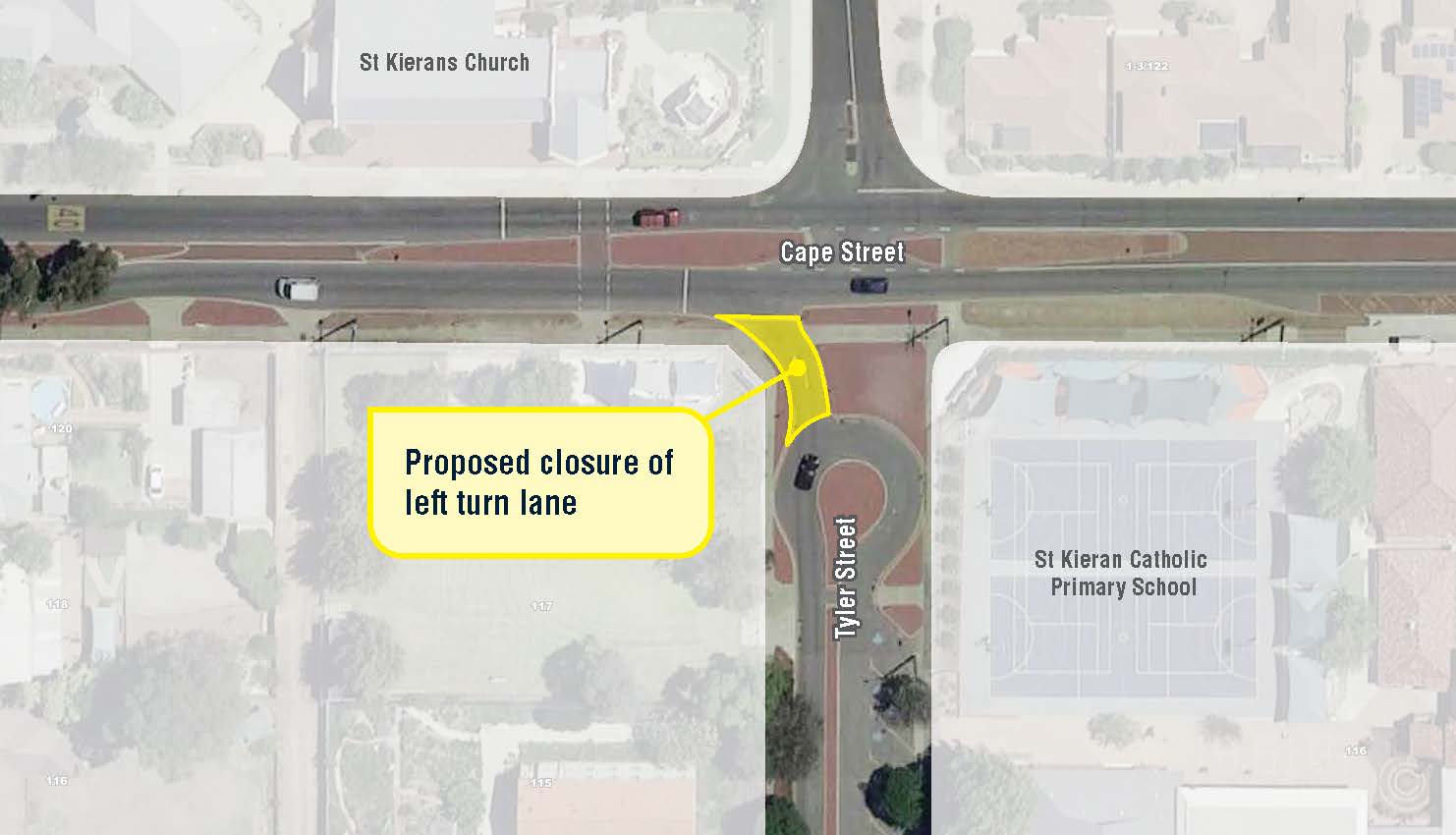
The trial closure of Tyler Street at the Cape Street intersection will begin in January 2026 and remain in effect for at least three months.
This initiative follows a community consultation held in September 2025, during which 193 responses were received – 81% in support and 19% opposing. Council endorsed the trial closure at its meeting on 25 November 2025.
The purpose of the trial closure is to assess the impact on the surrounding road network and to gauge community support for a permanent closure. For further information please refer to Item 12, Subject 12.2ES4 Proposed Trial Intersection Closure – Tyler Street and Cape Street, Tuart Hill within the Council Minutes of 25 November 2025 linked below.
Written objections or comments to the closure should be lodged with the Chief Executive Officer, City of Stirling, 25 Cedric Street, Stirling before 5.00pm, Thursday 22 January 2026.
Following the trial, the community will be invited to provide feedback on the closure.
View plan: Tyler Street and Cape Street Plan
Council Report Minutes: 28 May 2024 12 August 2025 and 25 November 2025
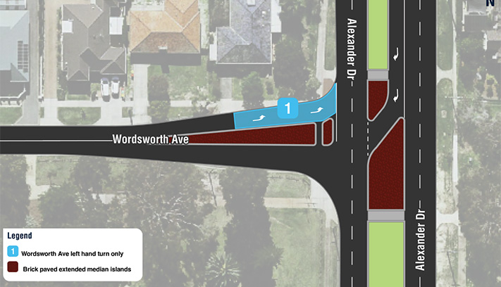
The City of Stirling is committed to improving road safety by enhancing the safety of the local road network. In response to resident concerns about speeding and driver behaviour along Karrinyup Road between West Coast Drive and Arnott Street, the City has explored several measures to resolve these issues.
Surveys conducted in 2023 recorded an average of 9,400 vehicles per weekday, with speeds slightly exceeding the 60km/h limit. Traditional traffic calming treatments such as speed humps, plateaus, and chicanes have been ruled out due to noise and safety concerns.
Proposed safety upgrade
The City is seeking feedback on the following proposed measures:
Local residents are advised that parking nibs will impact the manoeuvrability of rubbish collection trucks. The below plan shows the proposed treatment locations and bin placement for uninterrupted waste collection. On collection days, please avoid parking in front of bins.
Feedback on the proposed improvements will be presented to Council for consideration in the review of the 2025/2026 budget. Residents who respond will be kept informed of the outcomes.
View map: Karrinyup Road, Trigg Plan
Phase: Consultation closed (Monday 1 December to Monday 22 December)
The consultation on the proposal to improve safety at the intersection of Summerhayes Drive and Clement Drive has now closed.
Traffic data review
In response to community concerns, the City conducted a traffic data review. The review considered traffic volumes, vehicle speeds, crash history, road layout and nearby destinations such as shops, parks and schools. The review found that, based on current criteria, the intersection is a low priority for traffic or speed management changes.
Proposed safety upgrade
A report presented to Council on 1 July 2025 outlined two options for improvements at the intersection.
A minor redesign of the intersection, including consideration for a raised roundabout with a possible tree. However, adding a tree to the roundabout was not suitable due to limited space for vehicles and trucks to turn safely, risk of vehicle damage, and ongoing maintenance challenges.
A report detailing the outcomes of the community consultation will be presented to Council for consideration. Locals who have provided feedback will be kept informed of outcomes, and progress updates will be shared on this page.
View plan: Intersection of Summerhayes Drive and Clement Drive, Karrinyup
Phase: Consultation closed (Monday 3 November to Tuesday 2 December)
Council minutes: Meeting of Council - 1 July 2025
The consultation for the proposal to install five safety platforms and a zebra crossing on Davenport Street has now closed.
Traffic data review
A traffic data review in May 2024 revealed a significant increase in traffic volume in the area. Crash records from 2020 to 2025 show that 30 incidents have occurred on the streets surrounding the shopping centre, with 20 of these taking place on Davenport Street, 13 of these crashes involved vehicles exiting driveways. Recent community engagement also highlighted that road and traffic management is a top local priority for the suburb.
Proposed safety upgrade
The design will enhance safety by preventing and reducing the severity of traffic related incidents. Site-specific constraints, including driveway locations, road layout, and utility services have been considered. A plan of the proposal is included below.
Your feedback on the proposed safety improvements on Davenport Street will be considered in the City’s submission for Black Spot funding to the Federal and State Governments. Locals who provided feedback will be kept informed of the outcomes, and progress updates will be shared on this project page.
View plan: Davenport Street Plan
Phase: Consultation closed (Monday 3 November to Tuesday 2 December)
Council minutes: Meeting of Council - 27 May 2025
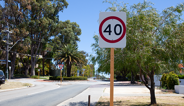
The consultation for the proposal to introduce a 40km/h zone to the local streets north of Karrinyup Road up to and excluding North Beach Road has now closed.
This change aims to reduce driver speed and improve safety for pedestrians, bike riders and drivers. Low speed limits on local streets have been shown to reduce the number and severity of crashes, creating safer, more liveable neighbourhoods.
A report detailing community feedback will be presented to Council for consideration.
View map: Map of proposed speed zone
Phase: Consultation closed (Monday 3 November to Tuesday 2 December)
Council minutes: Meeting of Council - 1 July 2025
The consultation on the Urban Road Safety Program has now closed.
During the consultation period, the City received 100 responses, with 69% in support of the proposal and 31% opposed.
Feedback highlighted community support for reducing vehicle speeds in the area with several respondents requesting the treatments be extended. The proposed treatments, including speed cushions and raised safety platforms, are designed for this purpose and will help support the reduction and severity of crashes.
With the support of Main Roads WA, the City will be proceeding with the proposal. Construction of the treatments will be scheduled in the current financial year.
View plan: Plan of treatment locations
Phase: Consultation closed (1 August – 22 August 2025)
View report: View the consultation report.
Anyone can nominate a ‘black spot’ for funding. Nominations for locations are invited from state and territory governments, local councils, community groups and associations, road user groups, industry and individuals. Find out more at the Department of Infrastructure, Transport, Regional Development, Communications and the Arts.
Funding is mainly available for the treatment of Black Spot sites, or road lengths, with a proven history of crashes.
The program recognises that there are road locations that could be considered as accidents ‘waiting to happen.’ Some program funds may be used to treat sites where a Road Safety Audit, undertaken by road traffic engineers, identifies that remedial work is necessary, allowing for proactive safety works to be implemented before an accident happens.
As part of the consultation process, it is important that the City gain community support prior to applying for project funding.
The City will consider all the submissions during the community consultation and report on findings within the submission process.
All requests regarding road safety issues and traffic assessments on local roads are managed by the City and evaluated under the City’s Traffic Management Warrants Policy. The policy ensures requests can be prioritised based on a range of safety and amenity factors including traffic volumes, travel speeds, crash history, road geometry, road users and activity generators.
Traffic counters provide the City with data on vehicle speed and volume and are installed as part of either the City’s ongoing traffic monitoring program, assessing developments or road changes or in response to resident concerns of speed and/or volumes along a road.
Maintenance of roads is partly funded by rates, with additional support provided through various road safety programs and grants funded by the federal and state governments.
The Black Spot Program directly targets hazardous roads with a proven crash history or locations identified as high-risk. In collaboration with Main Roads WA, the National and State Government funded program provides grants to make eligible local streets safer through community-led traffic calming initiatives. Treatments can include roundabouts and/or traffic signals.
The City’s success in obtaining Black Spot Program funding for projects within our road network has had a positive impact on the overall reduction of crashes.
The City of Stirling is currently working in collaboration with Main Roads WA to improve the safety of local roads and intersections.
In line with the City’s aim to provide safe roads and road systems, the City of Stirling and Main Roads WA have been working collaboratively on the Urban Road Safety Program (URSP) to improve the safety of local roads and intersections.
The URSP actively identifies and prioritises local neighbourhood areas with a higher-than-average casualty crash history. Generally applied area wide or with a whole of street approach, design and construction of these road treatments aim to address these issues by implementing a safe road environment which, when combined with appropriate travel speeds, will reduce the number and severity of crashes.
The URSP typically uses compact road safety treatments with the aim of reducing vehicle speeds and crashes in an area wide scheme that provides excellent value to the community.
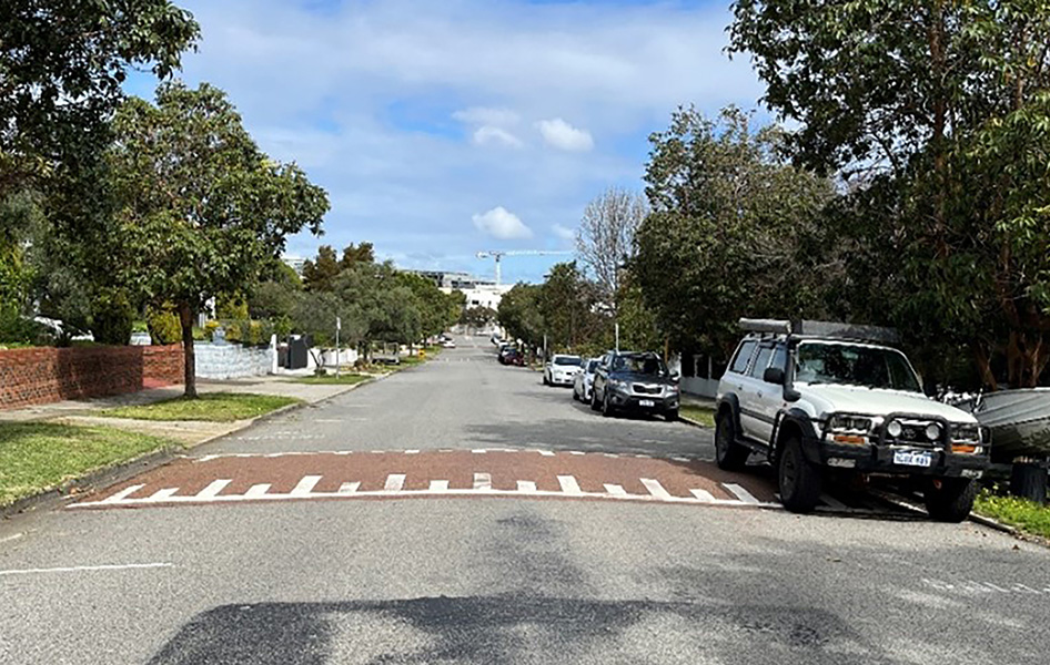
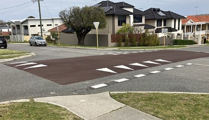
Example located at the intersection of Baden Street and Tyler Street, Joondanna. For further information, view the MRWA Raised Safety Platform Fact Sheet.
_914x498_jpg.jpg?width=681&height=371 "PLN_Urban-Road-Safety-Program-Balga_03-(1)_914x498_jpg")
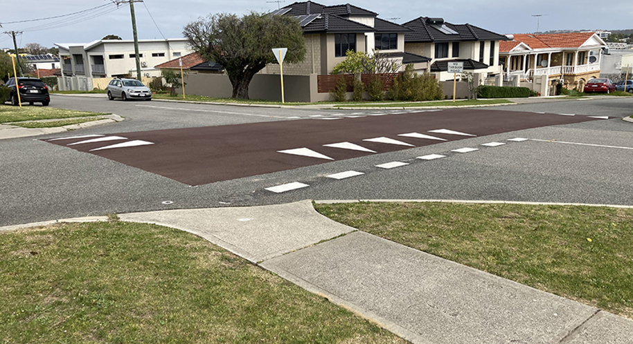
Example located on Camberwell Road, Balga.

Example from Town of Victoria Park. For further information view the MRWA Mid-Block Treatment Fact Sheet.
_946x600.jpg "END_Image-3-Midblock-Speed-Plateau-(Example-from-Town-of-Vic-Park)_946x600.jpg")
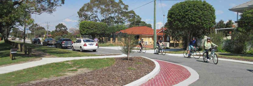
For further information, view the MRWA Compact and Mini Roundabout Fact Sheet.


Where required, existing kerbing affected by the works is replaced to City standards with a semi-mountable type profile. Different profiles may be used where justified. The resident is requested to avoid driving over the fresh concrete kerb for at least three days.
Existing painted house numbers affected by the works will be re-painted onto the new kerb where requested by the resident at the City's cost by an authorised contractor.
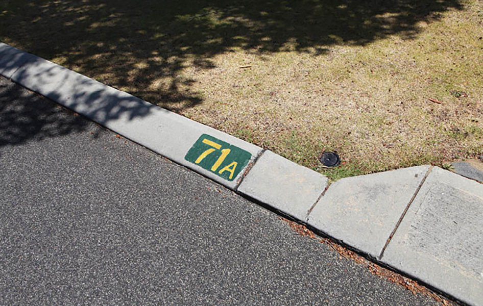_946x600.jpg "ENG_House-Numbers-on-Kerbs_TI-(1)_946x600.jpg")
Following construction, existing functioning reticulation systems affected by the works will be reinstated by the City's contractor at no cost to the resident. Please test and notify the City of any damage within two weeks of completion of work on the verge. It is advisable to test your reticulation systems 24 hours after any concrete works have been completed to allow the concrete to set.

Where existing plants are likely to be impacted by the works it is responsibility of the adjoining owner/occupier to make arrangements for them to be removed, stored, watered and replanted at the completion of the project.

The City will reinstate hardstand areas (brick paving, bitumen and in-situ concrete) in the verge affected by the works and will endeavour to match existing materials where reasonable, safe and legal. Reinstatement works will allow a clearance of 2m away from street trees.

The City values its trees and will protect them during the works including possible ground level adjustments for existing tree roots.

The City will reinstate lawn areas affected by the works with roll on turf where the width of the disturbed area is greater than 500mm. For widths 500mm or less, the disturbed area will be backfilled with clean yellow sand. The City will reinstate verge treatments that have been authorised and approved by the City but will not be responsible for reinstatement of verge treatments that are not of approved materials.

The City will reinstate lawn areas affected by the works with grass runners or grass planted randomly where the disturbed area has a width of greater than 500mm. For widths 500mm or less the City will backfill the disturbed areas with clean yellow sand.

The City will temporarily remove any artificial turf in the verge/footpath that may be impacted by the works and put it back to its original position after completion of the works. Whilst the City will take care not to damage the synthetic turf, the City will not undertake any reinstatements of illegal materials.

The City will reinstate organic mulch on the verge that is affected by the works.

Where it is clear an alternative informal vehicle access is occurring into a property and is affected by the works the City will install a 600mm wide concrete apron within the affected kerb.

The City will reinstate concrete crossovers that are affected by the works. The minimum reinstatement will be the removal and replacement of the first 2.05m from the front of the kerb to suit new road levels. For the first six (6) days after the concrete is poured, the resident is requested to avoid driving over the splays or edges of the crossover. Driving through the centre of the crossover splays is allowed after 3 days.

Asphalt or bitumen crossovers affected by the works will be reinstated by the City. Depending on the level of impact of the works and the new road levels, the City will replace the existing asphalt or bitumen crossover with a standard grey concrete crossover. This usually occurs where the impact is greater than 1.0m from the front of the kerb line.

Brick paving disturbed by the City shall be reinstated to tie in with the new works. Excess brick pavers shall be removed and disposed of by the City without cost to the owner/occupier. If you would like to retain excess brick pavers, please contact the City’s representative, as shown in the notification letter prior to the commencement of construction works.
Due to problems associated with matching colours, the non-availability of some older style pavers, and potential level differences, a 600mm wide concrete apron will be provided at the road edge for the full width of the crossover. Brick paved crossovers on the new footpath alignment will be replaced with grey concrete to match the new path and to maintain the continuity and visual delineation of the new footpath.

For local roads, new 600mm wide concrete apron may be installed to existing brick-paved driveways at no cost to owners or occupiers. The apron will be installed at the road edge for the full width of the crossover in varying depth to address potential level differences.
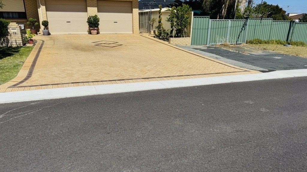.jpg "Image-(2).jpg")
The City will only reinstate non-standard crossovers affected by the works with standard grey concrete crossovers to a minimum distance of 2.05m from the front of the kerb. This will tie in with existing or possible future footpaths to maintain visual continuity of the footpath and in accordance with the City’s Crossover Policy.
For more information, or to receive this information in an alternate format, please contact the City on (08) 9205 8555 or visit www.stirling.wa.gov.au/enquiry.
City of Stirling kaadatj Nyoongar moort Nyoongar boodja-k Wadjak boodja-k. Ngalak kaadatj Nyoongar nedingar wer birdiya koora koora wer yeyi. Baalabang koondarm, malayin wer nakolak baalap yang ngalany-al. Ngalak dandjoo barn wer kaaratj bandang boodja-k.
The City of Stirling acknowledges the traditional custodians of this land, the Wadjak people of the Nyoongar Nation, and pays respect to the Elders both past and present for they hold the memories, the traditions, the culture and hopes of Aboriginal Australia.


.jpg?lang=en-AU)